
"A system to change the system"
- Introduction of GIS
- Scope of GIS
- The Spread of GIS in Pakistan
- GIS Projects & Impacts in Pakistan
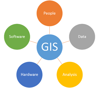
INTRODUCTION OF GIS (Geographic Information Systems)
�Geographic Information Systems is a computer-based tool that analyzes, stores, manipulates and visualizes geographic information, usually on a map.”
GIS Systems really come down to just 4 simple ideas:
§ Create & Capture geographic data
§ Manage it.
§ Analyze it and…
§ Display it on a map.
The geographic Information system deals with the mapping of earth, saving the coordinates of each place in computer and facilities available. When the database is linked by satellite, the information is available all over the world, like Google maps. But it also helps in planning, providing facilities to the community, gathering data to design and plan, and also in telecommunication and defense. So its applications are unlimited.
These days GIS underpins many technologies that we take for granted. Like the previously mentioned Google Maps, GIS is used in many other industries. It has been especially growing in fields like advertising, where location data is used to predict what products people might be interested in. GIS also shows up in things like driving directions and social media. Any aspect of someone’s life that involves geography or location is potentially affected by GIS technology.
Some of the largest problems of our planet are best understood spatially. For example, climate change, natural disasters, and population dynamics are all geographic in nature.
How do you solve problems in a GIS? The answer is through spatial analysis which understands relationships between spatial and attribute (Tabular) data.
Scope of GIS
Scope of GIS in Pakistan is unlimited. Following are few of the domains:· Civil Engineering
· Public Works Administration
· Property Mapping
· Telecom Services
· Academic Research
· Agriculture
· Transportation Planning
· Environmental Impact Analysis
· Fisheries
· Disaster Management
· Insurance
· Property Taxation
· Mining
· Geology
· Security
· Health
· Crime
· Climate Change
· Tourism
The Spread of GIS in Pakistan (Transforming the way we live) (Advantages)
GIS based geospatial technology has the power to transform lives significantly globally, and even in Pakistan.This global revolution in low-cost information and communication technologies can also help Pakistan address some of its oldest challenges with better planning, informed decision-making for stakeholders, and improved government service delivery to benefit citizens. GIS technology can also be explained in simple terms. Consider: At least 90 percent of everything a business, government, institution or organization does, it does ‘somewhere&rsquo. GIS effectively gathers geographical data, stores, and analyses it, and presents it in real-world spatial form.
Pakistan has the potential to be at the center of the GIS world and can make full use of the technology and its available applications. A country with a geographical high risk for emergencies such as floods and earthquakes, Pakistan can benefit immensely from GIS in flood risk mapping; such technology analyses historical data to detect potential flooding areas. Additionally, another example could be in case the transport department starts planning a new route for bus or railway system in Pakistan, GIS can analyze the best path that would cause the least disturbance to citizens and present it in the form of a map. This data can be accessible to the public and provide real-time updates.
Critics might argue about the lack of access to such information and technologies to the common man; however, creating awareness about the benefits of this technology can yield unimaginable results. In fact, an analytical study of such critical data can easily save a million lives in Pakistan.
Pakistan can effectively manage its resources, reduce duplication of facilities, and good governance can be encouraged with the use of GIS.
In Pakistan, the establishment of NSDI (National Spatial Data Infrastructure) is the need of the hour, whereas it can be defined as the technologies, policies, and people necessary to promote sharing of geospatial data throughout all levels of government, the private and non-profit sectors, and the academic community. Through this infrastructure, the duplication of efforts among different organizations can be reduced and Pakistan which already suffers from a lack of resources and good allocation systems can benefit from this immensely.
Pakistan is still catching up on GIS technology. However, many organizations have ventured fast into this development. The Urban Unit, The Space and Upper Atmosphere Research Commission (SPARCO), Planning and Development Department, Punjab Safe Cities Authority, and Pakistan Bureau of Statistics are a few of the entities that have developed advanced GIS systems. In this regard, the Urban Unit&rsquo's progress is noteworthy.
The Urban Unit has undertaken several projects under its GIS program, including Walled City Lahore Database and Marking of Royal Trail, GIS-based mapping of medical outlets, mapping of Vehicle Intensity of Sheikhupura City, mapping of parks, green belts, and roundabouts developed by PHA, mapping of government-owned buildings in Lahore, flood-prone areas of Punjab, UIPT GIS & MIS integration in Punjab 36 Districts and Sindh, Land Record Management Information System (LRMIS) Punjab, Punjab Spatial Strategy PSS (a spatial decision support systems) and many more. A number of Android-based applications have also been developed for monitoring.
Punjab Safe Cities Authority (PSCA) started a GIS-based system to control and manage the traffic and security in Lahore. PSCA generating e-challan with the help of GIS & MIS integration system. One more PSCA starting work on GIS Big data and machine learning (Image analysis) with new technologies. So they will be able to present live streaming security updates, analysis, and planning to overcome dangerous situations in all Punjab through GIS systems
One would anticipate that the available technology and data are put to good use for the government to plan holistically, formulate strategies to serve the community with risk mitigation, and deliver superior services.
The advancement in these technologies is a big step up for Pakistan and its frequent usage would provide the public and private sector a mechanism to devise result-oriented solutions based on analysis, leading to improved asset management, resource planning, and enhanced service delivery in Pakistan.
GIS PROJECTS & Impacts in Pakistan
1. Punjab Spatial Strategy
The Punjab Spatial Strategy (PSS) is a World Bank funded initiative being implemented by the Government of Punjab. The Punjab Spatial Strategy will assess the potential of Punjab�s growth corridors and growth nodes and prioritize and coordinate investments in the province. This strategy will inform in particular public investments related to connectivity infrastructure, urbanization and development of industrial zones, which will be reflected in the MDTF (Medium-Term Development Framework � a multi-year indicative budget) before approval through the ADP (Annual Development Plan � the annual budget) process.
The Urban Unit is the executing department/agency responsible for the development of the spatial strategy and will also implement capacity building necessary for linking this to the Medium and Annual Development Budget planning cycles in close collaboration with concerned relevant departments, local governments, and other stakeholders.
2. COMPUTERIZATION OF URBAN IMMOVABLE PROPERTY TAX
Excise, Taxation & Narcotics Control Department started GIS Integrated Computerization of Urban Immovable Property Tax (UIPT) in Sialkot District as a pilot project in 2013. The primary objectives of the project were to develop a robust system that should not only meet the requirements of the modern world but also have the characteristics of plugging all the avenues of leakages of revenue resulting in an increase in revenue, which apart from it should be transparent and user friendly.
It was envisaged that after successful completion of the pilot project in Sialkot, it could be extended to all the districts of Punjab. However, after successful completion of the pilot project, the Government of Punjab decided to extend it in Phase-I, to 5-Largest cities of Punjab including Lahore, Multan, Faisalabad, Gujranwala, and Rawalpindi, which generate almost 80% of the total revenue collection, which was supposed to be accomplished with 20% efforts.
These six districts, as a whole, have 2.2 million properties in which 1 million are taxable and the remaining are non-taxable. The successful implementation of this GIS-based system enhanced the speed of the work, quality, timely reporting, transparency, strong monitoring, reports generation, computerized PT-1, PT-10 Challan Forms.
After smooth system running for the last 3 years, the department finally decided to extend the GIS Integrated system of Computerization of UIPT in the remaining all 30 Districts of Punjab. Also Sindh GOVT decided in Sindh.
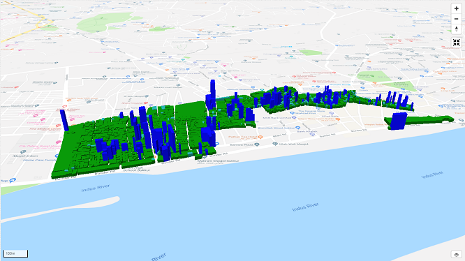
GIS & MIS Integrated 3D view of properties & Plaza
3. Asset Management of Pakistan Railways Land by GIS-Based Computerization and Development of Database Software for MIS
Pakistan Railways started work on GIS-based Land Management System of lands of Pakistan Railways. The project titled “ Asset management of Pakistan Railways Land by GIS-based computerization and Development of database software for MIS” of Pakistan Railways Land, is a vision of the present leadership to use technology for effective and efficient management of one of the most important assets i.e. land - economic corridor for the organization.
The current project is independently been acclaimed by various entities as one of the most successful automation projects completed over a period of the last two years. The Standing Committee of Senate and Asian Development Bank has appreciated the system developed jointly by Pakistan Railways and Urban Unit. This system is anticipated to become a Spatial Decision Support System for the land management of Pakistan Railways. The system may prove a new economic corridor for Pakistan Railways.
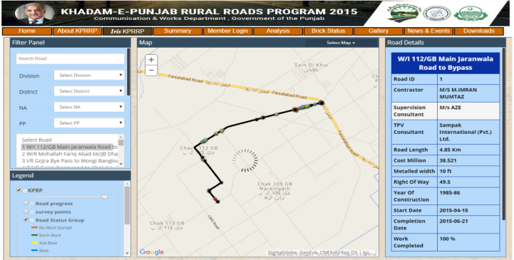
4. GIS-based Punjab Rural Roads Programme (PRRP)
Government of Punjab has launched the Punjab Rural Road Program (PRRP) - the biggest project of widening, repair, rehabilitation, and construction of rural roads in the history of Punjab. PRRP is aimed at laying a network of rural roads in all districts of the province while improving and rehabilitating existing roads that were in a deteriorated condition for quite some time. In addition to the reconstruction of these roads, the width of roads of rural areas will be increased from 10 feet to 12 feet.
In order to make the project a paragon and a model for future endeavors, multiple steps have been taken including third-party validation to maintain high standards of quality and GIS-based online monitoring of the project. The project will directly benefit the rural dwellers and will lead to the strengthening of the rural economy through better access to markets, schools, colleges, hospitals, and job opportunities.
For transparent monitoring physical work and financial utilization of these roads, they developed a web-based online system integrated with Geographical Information System (GIS) for real-time monitoring and view the data, progress, and comments/remarks uploaded by Communication & Works Department, Resident Engineers, Third-Party Consultants, and Visitors using GIS-Based android application. PRRP Monitoring dashboard provides a detailed summary, pictorial evidence, and geographical analysis of rural roads.
System based on:
o It shows the real-time physical progress and work done of each road along with road starting and ending picture as well as the location from where data is sent.
o An admin panel through which department can edit, update and add financial aspects of road. Department can also upload Third Party Validation of the road.
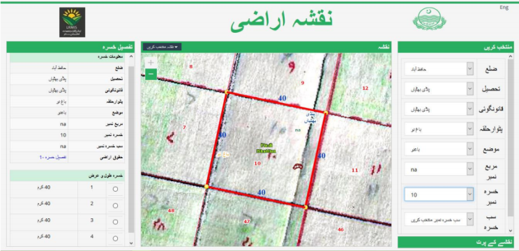
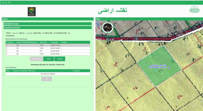
5. GIS Based Land Record Management Information System
Land Record Management System (LRMIS) project was developed for The Board of Revenue, Government of Punjab. The government started computerizing Land Records with overall objectives to improve service delivery and to enhance the perceived level of tenure security.
The project scope included all over the Punjab districts, initially started from the three districts (Lahore, Lodhran, and Hafiz Abad) of Punjab. The GIS-Based system has a mobile scanning capacity that will allow available musavees (local maps) of all three districts to be scanned and Geo-Referenced. Linkage of digitized musavees with Land Record Management Information System (LRMIS). Published data over the web to visualize the actual location, dimension, and detail information of �Khasra� (Parcel) and provided editing functionalities for GIS cadaster data.
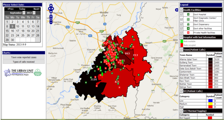
6. GIS-Based Disease and Vector Data Analysis Tool Punjab GOVT.
Disease Temporal Analysis Tool was developed for The Institute of Public Health, Government of Punjab. Punjab was traumatized by the worst epidemic of dengue, affecting thousands of people. Punjab Government wanted a statistical assessment tool that provides real-time town-wise patient count, occupied and available beds in the hospital. Two tools were developed, first shows the statistical count of diagnosed dengue patients and available beds information in the hospital, meanwhile, the second tool showed how the dengue epidemic spread in the districts of Punjab.
FUTURE OF GIS?
The future of GIS in Pakistan is very optimistic. It�s poised for even wider scale adoption than we�ve seen in recent decades, as more organizations learn how much business value can come from geospatial data. As trends like data analytics, mobility, augmented reality (AR), and the internet of things (IoT) continue to take off around the world, we can expect geographic information science and technology not only to be transformed but also to help change the way organizations utilize these technologies
comments
Абсолютно свежие новости моды. Абсолютно все новости всемирных подуимов. Модные дома, бренды, высокая мода. Интересное место для трендовых людей. <a href="https://ullafashion.ru/">https://ullafashion.ru/</a> <a href=https://ullafashion.ru/>https://ullafashion.ru/</a>
Абсолютно свежие события индустрии. Важные события всемирных подуимов. Модные дома, лейблы, гедонизм. Новое место для трендовых хайпбистов. <a href="https://gucci1.ru/">https://gucci1.ru/</a> https://gucci1.ru/
Несомненно свежие события мировых подиумов. Актуальные новости мировых подуимов. Модные дома, торговые марки, haute couture. Приятное место для стильныех хайпбистов. <a href="https://fashionessa.ru/">https://fashionessa.ru/</a> <a href=https://fashionessa.ru/>https://fashionessa.ru/</a>
Очень свежие новинки мира fashion. Важные события самых влиятельных подуимов. Модные дома, торговые марки, гедонизм. Новое место для стильныех людей. <a href="https://nbcollector.ru/">https://nbcollector.ru/</a> <a href=https://nbcollector.ru/>https://nbcollector.ru/</a>
Очень свежие новости подиума. Исчерпывающие эвенты известнейших подуимов. Модные дома, лейблы, высокая мода. Новое место для модных хайпбистов. <a href="https://fashionvipclub.ru/">https://fashionvipclub.ru/</a> https://fashionvipclub.ru/
Самые трендовые события мира fashion. Исчерпывающие эвенты мировых подуимов. Модные дома, бренды, haute couture. Новое место для стильныех хайпбистов. <a href="https://fashionvipclub.ru/">https://fashionvipclub.ru/</a> https://fashionvipclub.ru/
Абсолютно актуальные новинки индустрии. Важные мероприятия самых влиятельных подуимов. Модные дома, бренды, гедонизм. Свежее место для модных людей. <a href="https://balmain1.ru/">https://balmain1.ru/</a> https://balmain1.ru/
Очень свежие новости подиума. Актуальные эвенты всемирных подуимов. Модные дома, лейблы, haute couture. Самое приятное место для модных хайпбистов. <a href="https://metamoda.ru/">https://metamoda.ru/</a> <a href=https://metamoda.ru/>https://metamoda.ru/</a>
Наиболее важные новинки мировых подиумов. Актуальные новости всемирных подуимов. Модные дома, бренды, гедонизм. Новое место для модных хайпбистов. https://femalemoda.ru/
Самые свежие события индустрии. Актуальные эвенты самых влиятельных подуимов. Модные дома, бренды, гедонизм. Свежее место для модных людей. https://breakmoda.ru/
Style, luxe, travel Good fashion startpage for hypebeasts and stylish people. Podium news, events. New collections, collaborations, drops. https://dubai.luxepodium.com/
Избранные актуальные события мира часов - последние новинки лучших часовых брендов. Все варианты часов от недорогих до супер гедонистических. https://podium24.ru/
Полностью свежие новинки модного мира. Важные мероприятия известнейших подуимов. Модные дома, бренды, haute couture. Лучшее место для модных людей. https://furluxury.ru/
Самые важные новости индустрии. Исчерпывающие эвенты самых влиятельных подуимов. Модные дома, лейблы, высокая мода. Интересное место для модных людей. https://balenciager.ru/
Несомненно трендовые новости мира fashion. Важные новости всемирных подуимов. Модные дома, лейблы, высокая мода. Свежее место для модных хайпбистов. https://luxe-moda.ru/
Очень свежие новинки подиума. Важные эвенты лучших подуимов. Модные дома, торговые марки, гедонизм. Лучшее место для трендовых хайпбистов. https://fashion5.ru/
Полностью актуальные новости индустрии. Актуальные мероприятия лучших подуимов. Модные дома, торговые марки, haute couture. Самое лучшее место для модных хайпбистов. https://stylecross.ru/
Полностью стильные события мира fashion. Актуальные события мировых подуимов. Модные дома, лейблы, гедонизм. Самое лучшее место для стильныех хайпбистов. https://whitesneaker.ru/
Самые стильные события подиума. Важные мероприятия самых влиятельных подуимов. Модные дома, торговые марки, высокая мода. Лучшее место для стильныех людей. https://rfsneakers.ru
Самые актуальные события мировых подиумов. Абсолютно все новости известнейших подуимов. Модные дома, торговые марки, высокая мода. Самое лучшее место для трендовых людей. https://modavmode.ru
Точно свежие события подиума. Абсолютно все эвенты мировых подуимов. Модные дома, лейблы, высокая мода. Самое лучшее место для стильныех хайпбистов. https://miramoda.ru
Несомненно актуальные новости подиума. Актуальные события всемирных подуимов. Модные дома, бренды, гедонизм. Приятное место для модных людей. https://urban-moda.ru/
Точно трендовые новости подиума. Актуальные события самых влиятельных подуимов. Модные дома, лейблы, гедонизм. Самое приятное место для трендовых хайпбистов. https://sofiamoda.ru
Полностью стильные события мировых подиумов. Актуальные новости известнейших подуимов. Модные дома, бренды, haute couture. Интересное место для модных хайпбистов. https://fashionsecret.ru
Точно актуальные новинки модного мира. Абсолютно все события мировых подуимов. Модные дома, бренды, высокая мода. Свежее место для модных хайпбистов. https://worldsfashion.ru/
Полностью стильные новости индустрии. Абсолютно все мероприятия всемирных подуимов. Модные дома, бренды, haute couture. Лучшее место для трендовых хайпбистов. https://fashionablelook.ru
Самые важные новинки моды. Все события мировых подуимов. Модные дома, торговые марки, haute couture. Интересное место для трендовых людей. https://modavgorode.ru
Самые актуальные новости моды. Актуальные эвенты всемирных подуимов. Модные дома, бренды, haute couture. Самое приятное место для трендовых хайпбистов. https://myfashionacademy.ru/
Наиболее важные новости мира fashion. Абсолютно все мероприятия мировых подуимов. Модные дома, бренды, haute couture. Интересное место для модных людей. https://modaizkomoda.ru
Наиболее стильные новости индустрии. Все события известнейших подуимов. Модные дома, бренды, haute couture. Самое приятное место для трендовых людей. https://metamoda.ru/moda/599-doja-cat-vyzvala-bezumie-v-tope-i-yubke-iz-pishchevoy-plenki-s-rezhisserom-vetements-guram-gvasalia/
Несомненно актуальные события моды. Важные мероприятия лучших подуимов. Модные дома, торговые марки, haute couture. Лучшее место для модных хайпбистов. https://fashionvipclub.ru/news/2024-06-19-gruzin-kotoryy-perevernul-mirovuyu-modu-demna-gvasaliya/
Самые стильные новинки индустрии. Важные мероприятия известнейших подуимов. Модные дома, лейблы, высокая мода. Свежее место для стильныех людей. https://fashionvipclub.ru/news/2024-06-19-gruzin-kotoryy-perevernul-mirovuyu-modu-demna-gvasaliya/
Несомненно стильные новости мировых подиумов. Абсолютно все новости лучших подуимов. Модные дома, бренды, гедонизм. Самое лучшее место для стильныех хайпбистов. https://hypebeasts.ru/
Полностью трендовые новинки подиума. Абсолютно все мероприятия лучших подуимов. Модные дома, лейблы, haute couture. Свежее место для трендовых хайпбистов. https://luxe-moda.ru/chic/162-loro-piana-lyubimyy-brend-politikov-i-biznesmenov/
Самые важные события мировых подиумов. Все новости известнейших подуимов. Модные дома, торговые марки, высокая мода. Самое приятное место для модных хайпбистов. https://balmain1.ru/balmain/381-kak-otlichit-originalnyy-balmain-ot-poddelki/
Самые стильные новинки мировых подиумов. Все новости лучших подуимов. Модные дома, бренды, haute couture. Свежее место для стильныех хайпбистов. https://luxe-moda.ru/chic/356-rick-owens-buntar-v-chernyh-tonah/
Точно важные новости мировых подиумов. Важные мероприятия мировых подуимов. Модные дома, бренды, haute couture. Свежее место для трендовых людей. https://km-moda.ru/style/525-parajumpers-istoriya-stil-i-assortiment/
Точно свежие новинки моды. Абсолютно все мероприятия лучших подуимов. Модные дома, торговые марки, haute couture. Интересное место для модных людей. https://modastars.ru/
Точно стильные события мировых подиумов. Важные события всемирных подуимов. Модные дома, лейблы, гедонизм. Свежее место для модных людей. https://donnafashion.ru/
Самые актуальные новинки моды. Важные мероприятия известнейших подуимов. Модные дома, торговые марки, высокая мода. Свежее место для трендовых людей. https://mvmedia.ru/novosti/282-vybiraem-puhovik-herno-podrobnyy-gayd/
Leave a Reply
Your email address will not be published. Required fields are marked *